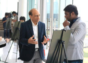
SOME HIGHLIGHTS OF STUDENTS’ RESEARCH
Strengthening students’ research conducted at AIT.
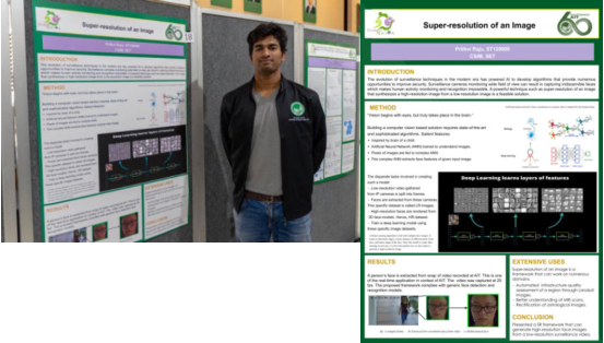
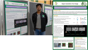
Super-resolution of an Image
Prithvi Raju
Master Student
Computer Science and Information Management
School of Engineering and Technology
"The
evolution
of
surveillance
techniques
in
the
modern
era
has
powered
Artificial
Intelligence
by
developing
algorithms
that
provide
numerous
opportunities
to
improve
security.
Surveillance
cameras
monitoring
wide
field
of
view
can
result
in
capturing
indiscernible
faces
which
makes
human
activity
monitoring
and
recognition
impossible.
A
powerful
technique
such
as
super-resolution
of
an
image
that
synthesizes
a
high-resolution
image
from
a
low-resolution image is a feasible solution."
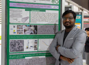
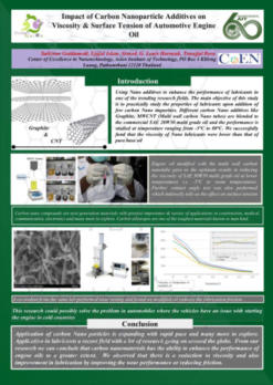
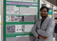
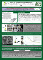
Impact of Carbon Nanoparticle Additive on Viscosity and Surface
Tensionof Automotive Engine Oil
Mr. Saikiran Gaddamedi
Master Student
Nanotechnology
School of Engineering and Technology
Using
Nano
additives
to
enhance
the
performance
of
lubricants
in
one
of
the
trending
research
fields.
The
main
objective
of
this
study
is
to
practically
study
the
properties
of
lubricants
upon
addition
of
few
carbon
Nano
impurities.
Different
carbon
Nano
additives
like
Graphite,
MWCNT
(Multi
wall
carbon
Nano
tubes)
are
blended
to
the
commercial
SAE
20W50
multi
grade
oil
and
the
performance
is
studied
at
temperature
ranging
from
-5℃
to
80℃.
We
successfully
fund
that
the
viscosity
of
Nano lubricants were lower than that of pure base oil.
Presented
and
was
one
of
the
Finalist
during
the
“
100
Innovations
x
Entrepreneurs”
event,
it
was
Southeast
Asia's
first
Research to Commercial (R2C) Conference.
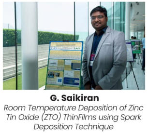
TRoom Temperature Deposition of Zinc Tin Oxide (ZTO) Thin
Films using Spark Deposition Technique
Mr. Saikiran Gaddamedi
Master Student
Nanotechnology
School of Engineering and Technology
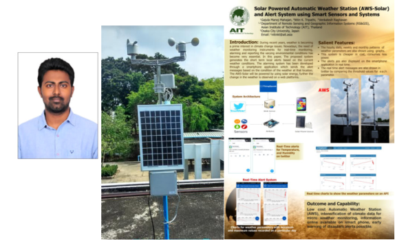
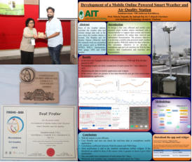
Solar Powered Automatic Weather Station (AWS-Solar) and Alert System using Smart Sensors and
Systems
Gajula Manoj Mahajan
Master of Engineering in Remote Sensing and Geographic Information
Systems ~ May 2017
School of Engineering and Technology
Signal & Telecom Technician @ Indian Railways, Hyderabad, India
(Government of India)
Introduction:
During
recent
years,
weather
is
becoming
a
prime
interest
in
climate
change
issues.
Nowadays,
the
need
of
weather
monitoring
instruments
for
real-time
monitoring,
alarming
and
reporting
the
varying
environmental
conditions
has
become
very
essential.
In
this
paper,
The
proposed
system
generates
the
short
term
local
alerts
based
on
the
current
weather
conditions.
The
alarming
system
has
been
developed
through
a
smartphone
application
which
sends
the
alert
messages
based
on
the
condition
of
the
weather
at
that
location.
The
AWS-Solar will be powered by using solar energy, further the change in the weather is observed on a web platforms.
Conclusion:
The
real-time
graphical
charts
are
displayed
on
the
smartphone
application.
The
hourly,
daily,
weekly
and
monthly
patterns
of
weather
parameters
are
also
shown
using
graphs.
The
upper
and
lower
threshold
values
were
fixed
in
the
application
for
individual
parameters.
The
real-time
alerts
are
shown
on
the
smartphone
screen.
The
real
time
alert
messages
are
also
shown in twitter using react application which will compare the conditions and gives real time alerts.
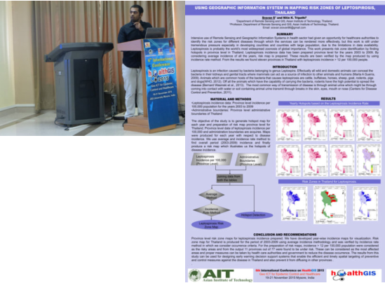
Using Geographic Information System in Mapping Risk Zones of
Leptospirosis, Thailand
Sravan Sajja
Master of Engineering in Remote Sensing and GIS ~ May 2016
Asian Institute of Technology, Thailand
Civil Works Contractor in Sarva Shiksha Abhiyan (SSA),
Guntur District, Andhra Pradesh, India
SUMMARY:
Intensive
use
of
Remote
Sensing
and
Geographic
Information
Systems
in
health
sector
had
given
an
opportunity
for
healthcare
authorities
to
identify
the
risk
zones
for
different
diseases
through
which
the
services
can
be
rendered
more
effectively,
but
this
work
is
still
under
tremendous
pressure
especially
in
developing
countries
and
countries
with
large
population,
due
to
the
limitations
in
data
availability.
Leptospirosis
is
probably
the
world’s
most
widespread
zoonosis
of
global
importance.
This
work
presents
risk
zone
identification
by
finding
hotspots
in
province
level
in
Thailand.
Leptospirosis
incidence
data
has
been
prepared
province
level
for
the
years
2003
to
2009.
By
considering
average
incidence
of
all
the
years,
risk
map
is
prepared.
These
results
are
been
verified
by
the
map
produced
by
using
incidence
rate
method.
From
the
results
we
found
eleven
provinces
in
Thailand
with
leptospirosis
incidence
>
12
per
100,000 people.
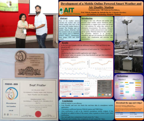
Karthikeya Nandanavanam VBS Sudarsan
Master of Engineering in Remote Sensing and Geographic Information
Systems ~ December 2018
PhD Fellow in Remote Sensing and Geographic Information Systems
Asian Institute of Technology, Thailand
Best Poster during FOSS4G-Asia 2018 held on December 2018 at Moratuwa,
Sri Lanka
Title: Development of a Mobile Online Powered Smart Weather and Air Quality
Station
Abstract: Most of the weather stations calculate the weather data and climate
change data only at the area where the weather station is located. The
Weather and Air Quality Station (W&AQ) built this research work are
assembled with sensors such as BMP280, DTH22, PM2.5, Anemometer, Rain
gauge, GPS and GSM module.
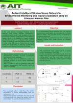
Karthik Muthineni
Master of Engineering in Information and Communication
Technology (ICT) ~ July 2018
Co-Researcher at National Electronics and Computer
Technology Center (NECTEC), Thailand
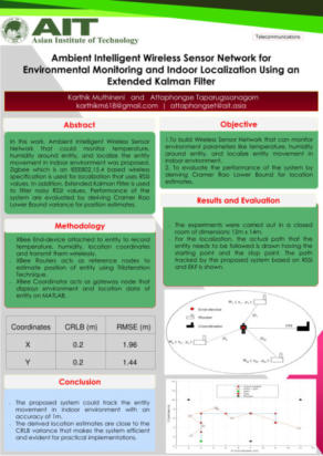
Thesis Title: Ambient Intelligent Wireless Sensor Network for
Environmental Monitoring and Indoor Localization Using an
Extended Kalman Filter.
Abstract:
Ambient
Intelligent
(AmI)
Wireless
Sensor
Networks
(WSN)
provide
intelligent
services
based
on
user
and
environment
data
obtained
by
sensors.
Such
networks
are
developed
to
give
environmental
monitoring
and
indoor
localization
services.
In
this
work,
Zigbee
which
is
a
wireless
communication
technology
is
used
for
localization
based
on
Received
Signal
Strength
Indicator
(RSSI)
method.
In
practice,
Extended
Kalman
Filter
(EKF)
is
adapted
to
filter
RSSI
values
influenced
by
multi-path
fading
and
noise.
Log-Normal
Shadowing
Method
(LNSM)
together
with
the
Trilateration
method
was
implemented
to
locate
the
position
of
the
unknown
node
or
entity.
In
addition,
Cramer
Rao
Lower
Bound
(CRLB)
is
derived
for
the
position
estimation,
that
can
be
used
to
evaluate
the
performance
of
the
system
in
terms
of
localization
accuracy.
Along
with
indoor
localization,
the
deployed
WSN
could
also
monitor
environment
parameters
like
temperature
and
humidity
surrounding
entity
using
digital
humidity
and
temperature
(DHT11)
sensor.
Using
Zigbee
location
coordinates
of
entity
and
environment
parameters
are transmitted to remote desktop where visualization of data is done using Matrix Laboratory (MATLAB).

NAVIGATION
ADDRESS
Asian Institute of Technology
58 Moo 9, Km. 42,
Paholyothin Highway
P.O. Box 4, Klong Luang
Pathumthani 12120 Thailand
CONTACT
o; Room 215, Admin Bldg
e: unified@ait.ac.th
f: (662) 524 - 6313


- About
- Partners
- BEIJING INSTITUTE OF TECHNOLOGY, CHINA
- CHIANG MAI UNIVERSITY, THAILAND
- COLLEGE OF INDUSTRIAL TECHNOLOGY, KMUTNB, THAILAND
- JNTU-HYDERABAD, INDIA
- JNTU-KAKINADA, INDIA
- KATHMANDU UNIVERSITY, NEPAL
- KING MONGKUT’S INSTITUTE OF TECHNOLOGY LADKRABANG, THAILAND
- KL UNIVERSITY, INDIA
- NATIONAL INSTITUTE OF TECHNOLOGY WARANGAL, INDIA
- SHANGHAI OCEAN UNIVERSITY, CHINA
- SIAM UNIVERSITY, THAILAND
- UNIVERSITY OF LIBERAL ARTS BANGLADESH
- VAN LANG UNIVERSITY, VIETNAM
- NATIONAL ECONOMICS UNIVERSITY, VIETNAM
- NGUYEN TAT THANH UNIVERSITY (NTTU), VIETNAM
- UNIVERSITY OF WEST BOHEMIA, CZECH REPUBLIC
- PETRA CHRISTIAN UNIVERSITY, INDONESIA
- Students
- Alumni Talks


SPECIAL DEGREE PROGRAMS


NAVIGATION
ADDRESS
Asian Institute of Technology
58 Moo 9, Km. 42,
Paholyothin Highway
P.O. Box 4, Klong Luang
Pathumthani 12120
Thailand
CONTACT
Email: unified@ait.ac.th


Some Highlights of Students’ Research
Strengthening students’ research
conducted at AIT
Super-resolution
of an Image
Prithvi Raju
Master Student
Computer
Science and
Information
Management
School of Engineering and Technology
"The
evolution
of
surveillance
techniques
in
the
modern
era
has
powered
Artificial
Intelligence
by
developing
algorithms
that
provide
numerous
opportunities
to
improve
security.
Surveillance
cameras
monitoring
wide
field
of
view
can
result
in
capturing
indiscernible
faces
which
makes
human
activity
monitoring
and
recognition
impossible.
A
powerful
technique
such
as
super-resolution
of
an
image
that
synthesizes
a
high-resolution
image
from
a
low-resolution image is a feasible solution."
Impact of Carbon Nanoparticle
Additive on Viscosity and Surface
Tensionof Automotive Engine Oil
Mr. Saikiran Gaddamedi
Master Student
Nanotechnology
School of Engineering and Technology
Using
Nano
additives
to
enhance
the
performance
of
lubricants
in
one
of
the
trending
research
fields.
The
main
objective
of
this
study
is
to
practically
study
the
properties
of
lubricants
upon
addition
of
few
carbon
Nano
impurities.
Different
carbon
Nano
additives
like
Graphite,
MWCNT
(Multi
wall
carbon
Nano
tubes)
are
blended
to
the
commercial
SAE
20W50
multi
grade
oil
and
the
performance
is
studied
at
temperature
ranging
from
-
5℃
to
80℃.
We
successfully
fund
that
the
viscosity
of
Nano lubricants were lower than that of pure base oil.
Presented and was one of the
Finalist during the “100
Innovations x
Entrepreneurs” event, it was
Southeast Asia's first
Research to Commercial
(R2C) Conference.
TRoom Temperature
Deposition of Zinc Tin
Oxide (ZTO) Thin Films using Spark Deposition
Technique
Mr. Saikiran Gaddamedi
Master Student
Nanotechnology
School of Engineering and Technology
Solar Powered Automatic Weather
Station (AWS-Solar) and
Alert System using
Smart Sensors and
Systems
Gajula Manoj
Mahajan
Master of Engineering in
Remote Sensing and
Geographic Information
Systems ~ May 2017
School of Engineering and Technology
Signal & Telecom Technician @ Indian Railways,
Hyderabad, India
(Government of India)
Introduction:
During
recent
years,
weather
is
becoming
a
prime
interest
in
climate
change
issues.
Nowadays,
the
need
of
weather
monitoring
instruments
for
real-time
monitoring,
alarming
and
reporting
the
varying
environmental
conditions
has
become
very
essential.
In
this
paper,
The
proposed
system
generates
the
short
term
local
alerts
based
on
the
current
weather
conditions.
The
alarming
system
has
been
developed
through
a
smartphone
application
which
sends
the
alert
messages
based
on
the
condition
of
the
weather
at
that
location.
The
AWS-
Solar
will
be
powered
by
using
solar
energy,
further
the
change
in
the
weather
is
observed
on
a
web
platforms.
Conclusion:
The
real-time
graphical
charts
are
displayed
on
the
smartphone
application.
The
hourly,
daily,
weekly
and
monthly
patterns
of
weather
parameters
are
also
shown
using
graphs.
The
upper
and
lower
threshold
values
were
fixed
in
the
application
for
individual
parameters.
The
real-time
alerts
are
shown
on
the
smartphone
screen.
The
real
time
alert
messages
are
also
shown
in
twitter
using
react
application
which
will
compare
the
conditions
and gives real time alerts.
Using Geographic
Information System in
Mapping Risk Zones
of Leptospirosis,
Thailand
Sravan Sajja
Master of Engineering in Remote
Sensing and GIS ~ May 2016
Asian Institute of Technology, Thailand
Civil Works Contractor in Sarva Shiksha
Abhiyan (SSA),
Guntur District, Andhra Pradesh, India
SUMMARY:
Intensive
use
of
Remote
Sensing
and
Geographic
Information
Systems
in
health
sector
had
given
an
opportunity
for
healthcare
authorities
to
identify
the
risk
zones
for
different
diseases
through
which
the
services
can
be
rendered
more
effectively,
but
this
work
is
still
under
tremendous
pressure
especially
in
developing
countries
and
countries
with
large
population,
due
to
the
limitations
in
data
availability.
Leptospirosis
is
probably
the
world’s
most
widespread
zoonosis
of
global
importance.
This
work
presents
risk
zone
identification
by
finding
hotspots
in
province
level
in
Thailand.
Leptospirosis
incidence
data
has
been
prepared
province
level
for
the
years
2003
to
2009.
By
considering
average
incidence
of
all
the
years,
risk
map
is
prepared.
These
results
are
been
verified
by
the
map
produced
by
using
incidence
rate
method.
From
the
results
we
found
eleven
provinces
in
Thailand
with
leptospirosis
incidence
>
12
per 100,000 people.
Karthikeya Nandanavanam VBS Sudarsan
Master of Engineering in Remote Sensing and
Geographic Information Systems ~ December 2018
PhD Fellow in
Remote Sensing and
Geographic
Information Systems
Asian Institute of
Technology, Thailand
Best Poster during
FOSS4G-Asia 2018
held on December
2018 at Moratuwa,
Sri Lanka
Title: Development of a Mobile Online Powered Smart
Weather and Air Quality Station
Abstract: Most of the weather stations calculate the
weather data and climate change data only at the
area where the weather station is located. The
Weather and Air Quality Station (W&AQ) built this
research work are assembled with sensors such as
BMP280, DTH22, PM2.5, Anemometer, Rain gauge,
GPS and GSM module.
Karthik Muthineni
Master of Engineering in Information
and Communication Technology (ICT)
~ July 2018
Co-Researcher at National Electronics
and Computer Technology Center
(NECTEC), Thailand
Thesis Title: Ambient Intelligent
Wireless Sensor Network for
Environmental Monitoring and Indoor
Localization Using an Extended
Kalman Filter.
Abstract:
Ambient
Intelligent
(AmI)
Wireless
Sensor
Networks
(WSN)
provide
intelligent
services
based
on
user
and
environment
data
obtained
by
sensors.
Such
networks
are
developed
to
give
environmental
monitoring
and
indoor
localization
services.
In
this
work,
Zigbee
which
is
a
wireless
communication
technology
is
used
for
localization
based
on
Received
Signal
Strength
Indicator
(RSSI)
method.
In
practice,
Extended
Kalman
Filter
(EKF)
is
adapted
to
filter
RSSI
values
influenced
by
multi-path
fading
and
noise.
Log-Normal
Shadowing
Method
(LNSM)
together
with
the
Trilateration
method
was
implemented
to
locate
the
position
of
the
unknown
node
or
entity.
In
addition,
Cramer
Rao
Lower
Bound
(CRLB)
is
derived
for
the
position
estimation,
that
can
be
used
to
evaluate
the
performance
of
the
system
in
terms
of
localization
accuracy.
Along
with
indoor
localization,
the
deployed
WSN
could
also
monitor
environment
parameters
like
temperature
and
humidity
surrounding
entity
using
digital
humidity
and
temperature
(DHT11)
sensor.
Using
Zigbee
location
coordinates
of
entity
and
environment
parameters
are
transmitted
to
remote
desktop
where
visualization
of
data
is
done
using
Matrix Laboratory (MATLAB).


SPECIAL DEGREE PROGRAMS